Geographical Information System
GIS Services and Solutions:
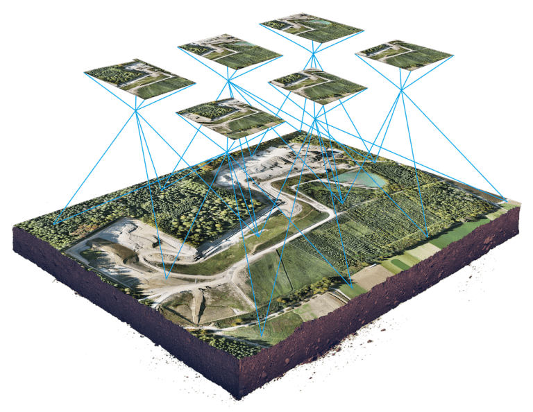
Wetech Solutions has prime focus in GIS industries on CAD and GIS Data creation, Data Migration, Data Conflation and Data Maintenance. We also provide services for Field Survey, Lidar, Remote Sensing, Data Processing and Customized Software and Tools for 2D and 3D GIS work. We take challenging assignments for all kind of CAD / GIS conversion works considering the strength of our team. We have highly specialized professional having years of experience in the domain area.
Conversion Migration, Conflation and Maintenance:
At Wetech Solutions, we use workflow processes for various GIS Data Activities:
- Enhancing, updating the legacy databases, which will also retain extensive information attached to existing features and vectors, while recreating features from the imagery and other input sources
- Interoperability of geo-databases for different data formats and software platforms
- Realigning geometric shapes to ensure positional accuracy, conflation, and retaining and/or updating attribute information
- Risk minimization through validation, workflows, and approval processes
- End-to-end visibility across tasks and schedules
- Consulting assignments for Enterprise GIS database design
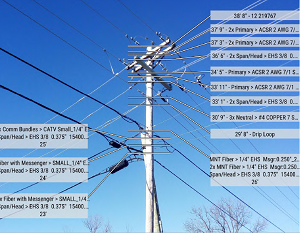
Pole Loading Analysis:
It is required to analyse the Existing and Future load on the pole to protect utility devices on that pole and safety measures as per the compliances like NESC (National Electrical Safety Code).
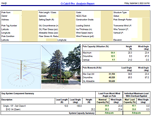
We are experienced working with AutoCAD, and pole structural analysis software, to perform electric utility pole loading analysis. Our team is capable to design and layout the Electric utility distribution system / Telecom utilities design in customer GIS and process platforms. We use the information from pole survey (provided by the client) and use the tools like O-Calc Pro, etc. to calculate the load on the pole and analyse that. We share the findings with the client which help them to eliminate and mitigate risks factors.
We provide solutions to utility companies If any new Electrical or Telecom device to be installed or replaced on the pole. Analysis to be done:
- Physical Survey at the location of the pole to collect the data using IKE4 devices, or catapult pro or other.
- Within the IKE4 software, annotate the relevant pole attributes including the attachment heights of existing cables and attachments.
- Full structural analysis of the pole, based of collected data, photos and if required, augmentation of existing pole loading.
- Using the best-in-class software like O-Calc Pro, EZ Load, SPIDACalc, etc. the Pole’s complete load calculation and stress analysis to be done before loading new device / replace the existing device and mapping for Wind, Fires, Storms and hurricanes.
- Provide a detailed analysis and report including high risk field assets in the form of spreadsheet or in the form & format acceptable by the utility company, Owner or Contractor which includes the nearest address, relevant pole information, and recommended make-ready changes that will be required for pole loading.
- Identify and report poles which lack proper information and are needed to complete make-ready (Revisits).
- Ensuring all the protection measures are met as per regulatory bodies requirements.
- Enables service providers to take decision for poles installation.
- Also pricing breakdown reports helps financial decision support. For example, if the cost of the pole exceeds $1000, the client may decide to bypass this pole.
-
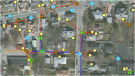
Utilities: Electric Gas and Telecom Network data creation & processing
1. Electrical, Gas, Telecom (Fiber, HFC, Copper)-ISP/OSP Network planning, Drafting and Model Design Development
2. Records Conversion and Integration
3. Historic service records and As-Built conversion & updates
4. Reactive Change-out & Field Order Forms Update
5. Work Order Processing and Posting into GIS
6. CAD/GIS Integration
7. Landbase and ROW/easement management
8. Establishing Connectivity
9. Data life cycle management
10. Data Conflation and Realignment
11. Technology Migration/Upgrade
12. Custom Application Development
13. Desktop, Web and Mobile Mapping
14. Enterprise Asset Management Integration with GIS -
Navigation & Mapping: Development and Maintenance of HD Maps for Autonomous Driving.
1. Standardized specification such as NDS and ADASIS standards, or custom specifications tailored for very specific use cases.
2. Road & street network capturing along with relevant features
3. POI data collection, process & Integration
4. Data Classification & Extraction
5. Attribution & Video labelling & feature extraction using front camera in vehicle or Inside Camera for indoor movements
6. Quality Control & Assurance
7. Enhancement & Enrichment of Existing Map Data Products. -
Land & Infrastructure:
1. Cadastral mapping
2. Land & Property Survey, data capture, Integration and management system
3. Topography and Geology mapping
4. Land use & Land cover (LU/LC) and Forestry & Agriculture Mapping
5. Land Records & Urban Planning & Mater Map -
Central, State and Local Government:
1. Municipal property survey, mapping & integration
2. Parcel Mapping
3. Urban land use mapping
4. Property tax mapping
5. Slum area mapping
6. Lidar Data mapping & processing
7. Departmental Geospatial requirement analysis & services - Well Experienced and dedicated Staff can work round the Clock 24X7.
- Capacity of producing 1000 orders/day with six sigma quality standards.
- Daily Flood Zone Determination:
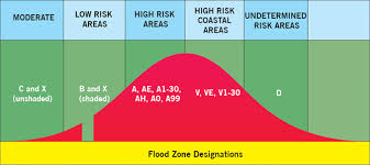
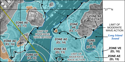
We complete Flood Zone Determination Request by providing the necessary flood information of the address. This is done by determining the location of the property on the FEMA. FEMA has defined according to different levels of flood risk. These zones are described on a community’s Flood Insurance Rate Map (FIRM) or Flood Hazard Boundary Map. Each zone reflects the severity of Flood in their respective areas or zones.
- Life of Loan (LOL) Flood Zone:
LOLs are processed to ensure continued compliance throughout the life of a loan. A LOL Update is only processed for those who have ordered Life of Loan Servicing. Searching history for orders with LOL Servicing, and re-checking the addresses previously submitted in the affected community is done to ensure that the flood insurance requirements have not changed when a New or revised Flood insurance Rate Map is processed. FEMA releases the new maps, called the “effective date”, we run a query on the entire LOL to determine which previously submitted addresses located requires a LOL Update. These addresses are compiled and remapped to update the new map parcel number and new parcel date, and to make sure that the community name, participation status, and flood zone information is accurate.
Benefits:
Industries
Flood Risk Insurance:
The Federal Emergency Management Agency (FEMA), has an easy tool that shows if your address is in a flood zone. The Flood Map Service Center shows information like flood zones, floodways, and the risk level your home faces.